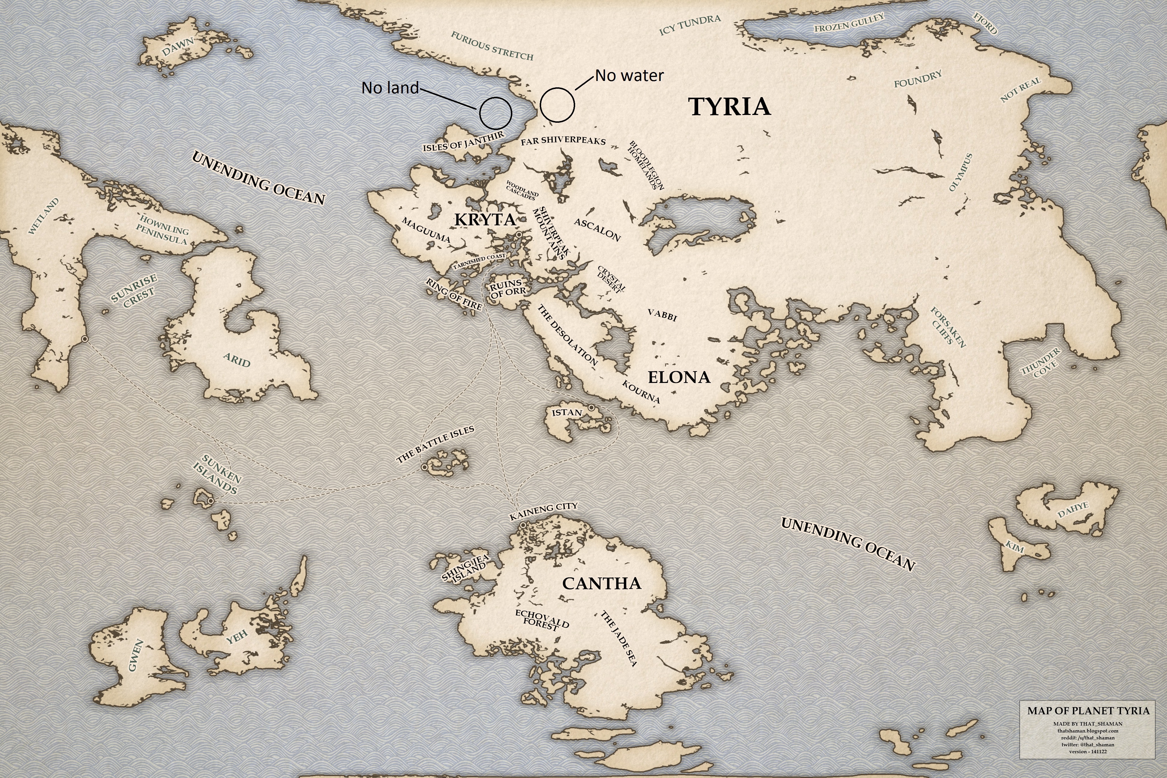
The map of Tyria (world) translated
You should’ve linked the thread: http://www.reddit.com/r/Guildwars2/comments/2n31yv/map_updated_high_resolution_map_of_planet_tyria/
Talk about obvious placeholder names being obvious. Though, I’m looking forward to traveling to the exotic lands of: Wetlands, Arid, Gwen, Yeh, and Kim. I hear they’re wonder this time of year.
Talk about obvious placeholder names being obvious. Though, I’m looking forward to traveling to the exotic lands of: Wetlands, Arid, Gwen, Yeh, and Kim. I hear they’re wonder this time of year.
You forgot to add Dahye to your list; it’s also a staff members name
Don’t forget “Not Real”
Talk about obvious placeholder names being obvious. Though, I’m looking forward to traveling to the exotic lands of: Wetlands, Arid, Gwen, Yeh, and Kim. I hear they’re wonder this time of year.
Fun fact: Gwen Yeh and Kim Dahye are two artists at Anet.
Wouldn’t doubt that they made the map and this was them signing it. :P
A lot of ancient maps are labeled more with descriptions rather than actual names when little is known of the land. Until Anet either decides what’s there for real, or is ready to reveal it, I think this is the best we’ll get.
Correction: The “Foundry” on the map is actually “Misandry”.
Whom shall we face in that distant land? Angry man-hating Amazons?
There’s many comments that can be made on this, truth be told. But as I’m sure that’d result in a finger-wagging by devs, I’ll say naught, even if they’re not my thoughts… until lately, at least.
Most of you will know what I mean either way.
Dear ANet writers,
Stop treating GW2 as a single story. Each Season and expansion should be their own story.
Stop treating GW2 as a single story. Each Season and expansion should be their own story.
Tyria is not a globe. It’s a Torus. A donut.
Tyria is not a globe. It’s a Torus. A donut.
There’s absolutely no evidence to support that >.> (in fact most evidence points to the contrary, it would be a bit weird if a planet that’s littered with observatories had no clue that it was doughnut shaped). I’m going to assume that you’re saying that because the texture is a square… It’s a lot easier to make a square texture than one that will actually fit around a globe. Of course they could do it, but, as the giant map sitting right before me suggests, there’s absolutely nothing wrong with having a square map; square maps are usually a little bit easier for people to comprehend.
Actually, there is some evidence – via only the texture – for Tyria (the world) being a torus shape. The east/west ends match up, as do the north/south ends. Two fun facts about rectangular/square world maps:
- Usually on such maps, it’s only the east/west ends, where the north and south ends are stretched out into being the same ‘dot’ location (this is why Antartica covers the full bottom of a world map of Earth); this is not so for the Tyria texture.
- Globe maps put into a square also feature a north-south elongation of locations the closer to the polar caps you see, caused once more by taking a spherical shape and making it square. This is why on world maps Greenland often appears the size of South America – it very much isn’t. This, once more, does not appear to happen on the Tyria texture.
This results in either there being distortions on the central ends of the north and south sides of the sphere (where the poles would be, theoretically at least), or the texture is not meant to be on a sphere, but a torus.
All lore statements and in-game models however point to Tyrians believing that the world is a sphere.
Dear ANet writers,
Stop treating GW2 as a single story. Each Season and expansion should be their own story.
Stop treating GW2 as a single story. Each Season and expansion should be their own story.
Given that from every location on Tyria we have ever been they’re able to experience the full orbit of the planet around the sun and can also see the stars – it’s a spherical planet. If Elona is equatorial, which it is heavily suggested to be, then Cantha would have to be on an interior plane of the torus, their view if it were would be quite different to what the rest of Tyria can see.
Arguably, that first point isn’t true, as what we experience with seasons and even days is questionable – potentially due to mechanics. Snow has never been seen to happen naturally during winter except in high elevation areas (mountains) and with comments or observations of the snow being magical (Kamadan’s snow, for example, during Wintersday in GW1 was said to be magically created; the snow seen in LA and elsewhere in GW2 during Wintersday shows up only beneath asuran snow-making devices). You can observe the sun rising and setting in the same direction – despite it being easy to set it to rise and set in opposing directions with mechanics – canon lore or laziness? We can’t say.
The existence of stars doesn’t make the place a planet. You can see stars from the Realm of Torment, which is a series of broken landscapes. And Margonites refer to Tyria as a “realm” just like Tyrians refer to the Underworld, Fissure of Woe, and Realm of Torment as realms.
And there’s an issue with your argument of Cantha being on the interior: since a torus wouldn’t really have a “north” and “south” who’s to say that the equator doesn’t run vertically rather than horizontally? Under such a notion, Tyria, Elona, and Cantha would have the same kind of night sky (stars) rather than seeing the “other side of the world” (which would be viewable if you go far enough west or east under such a concept).
Dear ANet writers,
Stop treating GW2 as a single story. Each Season and expansion should be their own story.
Stop treating GW2 as a single story. Each Season and expansion should be their own story.
On the torus theory- thanks to the grid on the new map, it can be seen that the east and west don’t line up. The western landmass extends a subsquare farther south than the eastern one.
R.I.P., Old Man of Auld Red Wharf. Gone but never forgotten.
I hope they start with expansions soon, all these continents and islands and we’ve seen barely anything of it, even counting Cantha and Elona.
You don’t win friends with salad! Sorry I just got caught up in the rhythm.
Arguably, that first point isn’t true, as what we experience with seasons and even days is questionable – potentially due to mechanics. Snow has never been seen to happen naturally during winter except in high elevation areas (mountains) and with comments or observations of the snow being magical (Kamadan’s snow, for example, during Wintersday in GW1 was said to be magically created; the snow seen in LA and elsewhere in GW2 during Wintersday shows up only beneath asuran snow-making devices). You can observe the sun rising and setting in the same direction – despite it being easy to set it to rise and set in opposing directions with mechanics – canon lore or laziness? We can’t say.
Winter doesn’t = snow. I live in an area where it does not snow, ever. The closest I can get to snow is a 4 hour drive to a mountain/volcano, which has snow on it because it is at a high altitude, not because of the season. That does not, however, mean that I don’t experience winter. Also there’s nothing to say that Tyria isn’t a bit closer to its sun than Earth is to our sun, or that any number of other variables aren’t factoring in that mean we don’t observe winter snowfalls in Tyria (or of course it could just be that the devs didn’t want to implement mechanics that would show it).
As to the equator potentially being vertical in order to support a doughnut world theory – that doesn’t really make any sense given the climate of the areas we can observe, and if you want to add that map’s labels then there’s even less likelihood of the equator being anywhere other than in the center of the map horizontally.
@Aaron: Interesting, however, people have cut and pasted the other texture before and it lined up perfectly. It’s possible that a smidget was removed from the Priory texture, perhaps.
@FlamingFoxx: Places that don’t snow are due to warmer climates. The reason for such changes – closer to the equator or due to warm wind currents (reason why some of Europe isn’t as cold as other places of equal latitude).
Kryta, however, appears to be far enough away from the equator and without any warm wind currents that either shouldn’t be effecting it.
And the state of snow in GW2 during Wintersday is very important to note: they did decorate all of Lion’s Arch, but once you leave the city proper the snow stops, as do the snow devices; they redid the entire map, but intentionally didn’t snow the entire zone. They also altered the five racial cities and starter areas, yet only enough to have the snow devices and “magical snow” piles. At the very least, if Kryta were to snow naturally, you’d think all of Lion’s Arch would be snow-covered.
As to your comment on equator and climates – the logic you provide works for a sphere, but not quite for a torus shape world.
In the end, however, I do think that it is on a sphere. However, I was merely pointing all of this out because your statement “there’s absolutely no evidence to support that >.>” (“this” referring to Tyria possibly being torus shaped) is false. Because there is evidence to support it, even if it is more likely to be a sphere.
Dear ANet writers,
Stop treating GW2 as a single story. Each Season and expansion should be their own story.
Stop treating GW2 as a single story. Each Season and expansion should be their own story.
One question that comes to mind after seeing that map. If Tyria is so vast, why are all the 6 Elder Dragons all concentrated into a tiny little corner of the world? How come there’s no Elder Dragon in Elona? Or Cantha? Or Gwen Yeh or Not Real? :P
@Konig Are you sure? Trying for myself, that version doesn’t line up either, unless we accept that there’s a length of coast roughly as long as Orr that happens to both run exactly north to south and be on the very edge of the map.
R.I.P., Old Man of Auld Red Wharf. Gone but never forgotten.
One question that comes to mind after seeing that map. If Tyria is so vast, why are all the 6 Elder Dragons all concentrated into a tiny little corner of the world? How come there’s no Elder Dragon in Elona? Or Cantha? Or Gwen Yeh or Not Real? :P
Short version- they aren’t as concentrated as they look (we’re looking at four in a region roughly proportional to our Russia) and it’s also the area surrounding where the Bloodstone was made- that is, where their entire remaining food source was consolidated.
R.I.P., Old Man of Auld Red Wharf. Gone but never forgotten.
(edited by Aaron Ansari.1604)
That is a fair point. At the time of their last hibernation, all the world’s magic was concentrated close to Arah due to the Bloodstones, so it does make sense they’d have migrated there in the closing days of their last rise.
Still, from our travels in Elona and Cantha, the rest of the world is still a highly magical place, so I’m a bit puzzled as to why the Elder Dragons haven’t struck out for more distant realms with less “competition”.
Some, hell, most of them might have. Kralkatorrik was last seen not too far from Elona , and we’ve got no idea where Bubbles, Jormag, or Primordus currently are romping. That leaves Zhaitan, who woke up beneath the perfect magic-fueled army of undeath starter kit, and Mordremoth, who has just woken up, not to mention, according to NPC speculation, may literally be rooted in place.
R.I.P., Old Man of Auld Red Wharf. Gone but never forgotten.
(edited by Aaron Ansari.1604)
One question that comes to mind after seeing that map. If Tyria is so vast, why are all the 6 Elder Dragons all concentrated into a tiny little corner of the world? How come there’s no Elder Dragon in Elona? Or Cantha? Or Gwen Yeh or Not Real? :P
We don’t have a concrete answer but there’s a few things of note:
- Technically speaking, only 4 Elder Dragons woke up in our neighborhood of Tyria. Jormag was far north of it, and the DSD awoke whoknowswhere.
- Going off of known lore of the past dragon rise, Zhaitan and Mordremoth’s influence are next to none. Arah was apparently Forgotten/Kralkatorrik territory, and Kralkatorrik’s territory spanned from Orr to the Crystal Desert to Blood Legion Homelands (where he fell asleep). Mordy and Zhaitan’s presence seems to have been very late. Jormag had mentions, but his main influence would be Drakkar and the Sanguinary Blade. Primordus had quite a bit of references too – but all via his champions and the dwarves (and for all we know, the dwarves were refugees like most modern races in the continent – like asura, skritt, kodan, quaggan, krait, etc. etc.).
- The world was drained of magic, all of it that wasn’t corrupted/consumed already being placed in the Bloodstone. Thus the Elder Dragons’ final meal was all placed into one nice buffet located in Tyria – this would undoubtably attract their attention. The DSD seems to have awoken not too far from the krait civilization (if not right underneath them) which had the Bloodstone-like Krait Obelisks, which would explain its distance if proximity is caused by the Bloodstone.
- Teeeechnically speaking, while the jotun have legends of six “swallowers” ending the world several times over, there’s no concrete evidence to say there isn’t more than six Elder Dragons. Yes, we have the six spheres… but what if two Elder Dragons share a single sphere? Unlikely, but plausible.
@Konig Are you sure? Trying for myself, that version doesn’t line up either, unless we accept that there’s a length of coast roughly as long as Orr that happens to both run exactly north to south and be on the very edge of the map.
I’ve seen such maps and there was no straight line so… pretty sure?
Still, from our travels in Elona and Cantha, the rest of the world is still a highly magical place, so I’m a bit puzzled as to why the Elder Dragons haven’t struck out for more distant realms with less “competition”.
They rather have, actually.
- Primordus has been busy digging through the ground. His location hasn’t been known for ages. And keep in him that there were six great asuran cities lost when the asura surfaced – each put on par to modern Rata Sum. Hello buffet!
- Kralkatorrik has been MIA for 7 years now, after he flew off from the battle with Destiny’s Edge. He could have easily flown off east or west. Or remained in place, since the Crystal Desert does have some nice lovely magical artifacts. Also keep in him that the Dragonbrand itself is expanding, slowly but surely.
- Zhaitan pushed his armies not just north, but west (to the Ring of Fire) and southwest (towards Elona). He would have spread further, but Lion’s Arch, Joko, and the vast seas kept his armies at bay – and Zhaitan seems to be one who would just simply sit on his proverbial throne and let his minions do everything (even his eating!).
- Jormag not only pushed south, but north into the arctic seas as well. He may be pushing east and west too, far to the north near where he woke, thus with unknown influence to our knowledge. He has also been pushing into the Mists themselves via the Sons of Svanir.
- The DSD is just simply unknown, and could have had over 150 years to spread about (or just 50) with supposedly nothing to oppose him in the ocean depths (as even the ferocious krait and karka flee from him – seems only the largos remain battling the DSD’s forces).
- Mordremoth just awoke, and while we only see him pushing east and potentially south (speculation places him in Magus Falls, thus south of where we are), nothing says he’s not pushing west – though there’s a coast not too far from him that way.
Dear ANet writers,
Stop treating GW2 as a single story. Each Season and expansion should be their own story.
Stop treating GW2 as a single story. Each Season and expansion should be their own story.
A few things to note – If you look at the map texture where it’s used, in the priory library, the east-west sides line up, if not perfectly, but close enough – there’s only a small visible seam where the texture edges connect. Secondly, if you look at the globe model also found in the priory library, there is sea at the northern cap, and that huge straight coastline to the north is contracted a lot. I wouldn’t put the borders of the texture above that.
Only fools and heroes charge in without a plan.
Tyria is not a globe. It’s a Torus. A donut.
There’s absolutely no evidence to support that >.> (in fact most evidence points to the contrary, it would be a bit weird if a planet that’s littered with observatories had no clue that it was doughnut shaped). I’m going to assume that you’re saying that because the texture is a square… It’s a lot easier to make a square texture than one that will actually fit around a globe. Of course they could do it, but, as the giant map sitting right before me suggests, there’s absolutely nothing wrong with having a square map; square maps are usually a little bit easier for people to comprehend.
Do you even science?
Look at Earth’s map. Walk north of the north pole and you won’t magically appear on Antartica. The map of Tyria dictates a Torus shaped world.
/thread
You are not referring to a map. You are referring to a map texture. It’s never once used ingame in a way that would portray land at the north pole – as I stated in the post just above you, the globes in Priory library show that the continent doesn’t reach the north pole, the part that looks like the south pole on the texture is the northern edge of the continent.
Only fools and heroes charge in without a plan.
I feel like we as players could be the only ones who don’t know the shape of the world. Most likely not toroidal though, as at SOME point you’d be able to see the planet stretch upward onto the horizon. Not to mention see a landscape in great detail when looking through a telescope (like the one in Orr). Unless the Tyria we know is only a REMARKABLY small spot on the outer edge of the planet.
Also, in GW1 Cantha, there was an outpost with intricately designed stellar maps, and an “astrolarium” in Istan. Between all these people obsessing over stars, I have a hard time thinking that someone hasn’t come up with a general shape of the planet.
Leader and sole member of the “Bring Penguins to Tyria” movement.
I feel like we as players could be the only ones who don’t know the shape of the world. Most likely not toroidal though, as at SOME point you’d be able to see the planet stretch upward onto the horizon. Not to mention see a landscape in great detail when looking through a telescope (like the one in Orr). Unless the Tyria we know is only a REMARKABLY small spot on the outer edge of the planet.
Also, in GW1 Cantha, there was an outpost with intricately designed stellar maps, and an “astrolarium” in Istan. Between all these people obsessing over stars, I have a hard time thinking that someone hasn’t come up with a general shape of the planet.
Humans have been obsessing about the stars for milennia, yet the true shape of the world wasn’t accepted fact until a few centuries ago. It seems obvious to us now… in hindsight. People back then generally didn’t think the way we do.
You are not referring to a map. You are referring to a map texture. It’s never once used ingame in a way that would portray land at the north pole – as I stated in the post just above you, the globes in Priory library show that the continent doesn’t reach the north pole, the part that looks like the south pole on the texture is the northern edge of the continent.
“You are referring to a map texture. It’s never once used ingame in a way that would portray land at the north pole”
What does that even mean? All that does is prove my point… there is no north pole, because it’s not a bloody sphere.
“the continent doesn’t reach the north pole, the part that looks like the south pole on the texture is the northern edge of the continent.”
Which is impossible in case of a sphere, so thanks for once again proving my point.
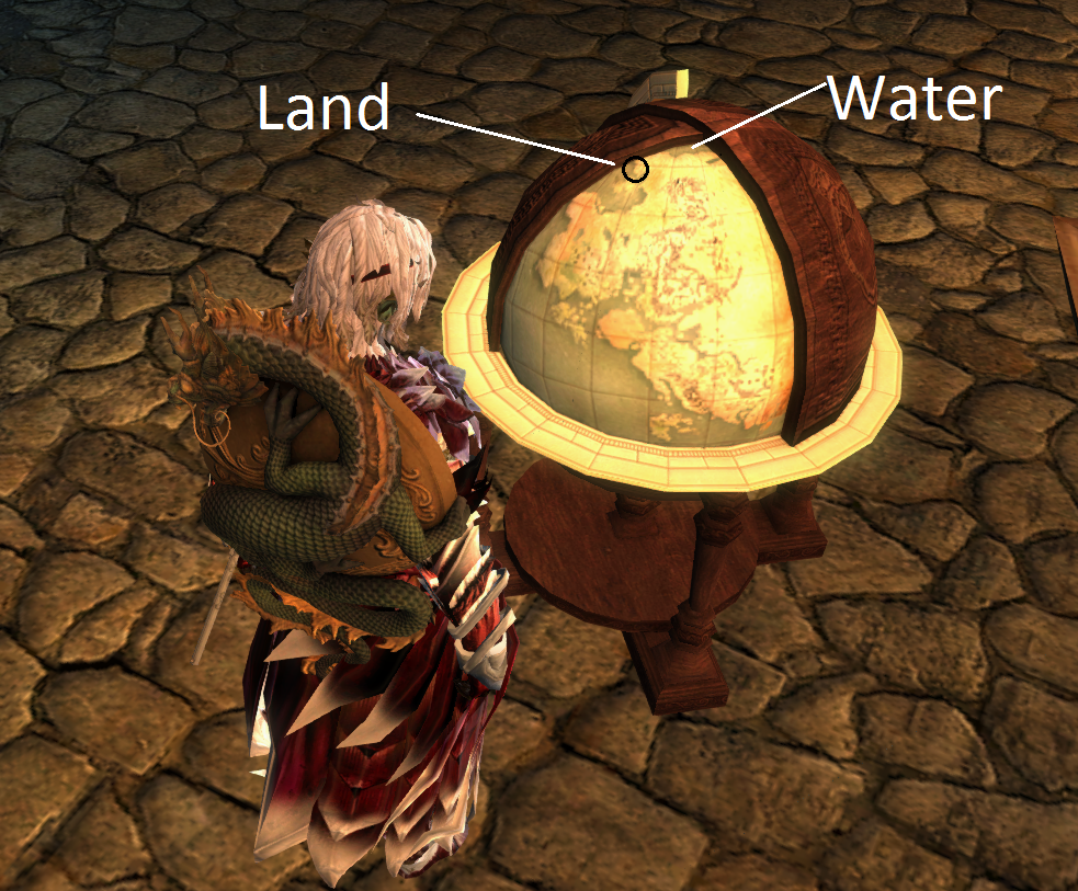
You are missing the point. Your assumption is based on the texture connecting on the southern and northern edges. However, those edges aren’t the true edges of the map, based on the globe. Take a look at the attached image – do you recognize the northern shore? The map doesn’t warp around north-south, the texture is simply laid out in a way it’s not supposed to be looked at, for whatever reasons.
Attachments:
Only fools and heroes charge in without a plan.
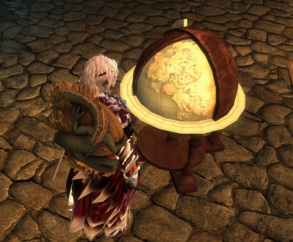
What I find interesting about that globe texture is that it shows the landmass of Tyria curving around the isle of janthir, as shown in the EOTN map, yet that landmass is missing in the “world maps”
what is also interesting is that if you look closely you can see that the shiverpeaks, and the Tyrian landmass, end a little bit north of where frostgorge sound is, and there’s water up there, which is also not present on the world map.
See attachment
Attachments:
On the very corner of the visible area of the globe, you can see the shape of Frozen Gulley – the map projection on the “world map” just makes the objects near the poles appear far larger than they are, just as is with any map of a round object spread flat in a rectangle. You can see the land and water you marked on the globe further up on the “world map”, the northern sea of the world map texture just so happens to be on the southern edge, my guess is that it’s to make the texture continuous easier, like they did with the floor in the Priory library. But, as the edges of the “world map” texture are never used in the game as they are, they can’t be considered canon, which means the globe draws the northern shore correctly or at least is the most likely to hold true.
Only fools and heroes charge in without a plan.
You are not referring to a map. You are referring to a map texture. It’s never once used ingame in a way that would portray land at the north pole – as I stated in the post just above you, the globes in Priory library show that the continent doesn’t reach the north pole, the part that looks like the south pole on the texture is the northern edge of the continent.
“You are referring to a map texture. It’s never once used ingame in a way that would portray land at the north pole”
What does that even mean? All that does is prove my point… there is no north pole, because it’s not a bloody sphere.
“the continent doesn’t reach the north pole, the part that looks like the south pole on the texture is the northern edge of the continent.”
Which is impossible in case of a sphere, so thanks for once again proving my point.
You are missing the point. Your assumption is based on the texture connecting on the southern and northern edges. However, those edges aren’t the true edges of the map, based on the globe. Take a look at the attached image – do you recognize the northern shore? The map doesn’t warp around north-south, the texture is simply laid out in a way it’s not supposed to be looked at, for whatever reasons.
I’ll just point this out now.
Those globes use an entirely different texture, which can be found here. (note: original was on the wiki and was deleted, unfortunately) – the two are completely different textures, and the one on the globe only details Tyria, Elona, and Cantha. The super-continent of Tyria isn’t even the same between the two. Furthermore, the one of the globe you refer to is an ArenaNet alteration of this fan-made map seen here.
As you can see by the player-altered version of the texture, it did not show the landmasses now labeled “Gwen” “Yeh” Dahye" “Kim” “Arid” “Wetlands” “Sunken Islands” etc. It did have some land portrusions on and near the corners, but it is not a complete map of the world.
I’ll ask that_shaman to see if he can pull the globe’s map texture out, to see if that was changed at all.
Dear ANet writers,
Stop treating GW2 as a single story. Each Season and expansion should be their own story.
Stop treating GW2 as a single story. Each Season and expansion should be their own story.
People have actually know the world was not flat for MUCH much longer than most people believe. It’s generally accepted that most people thought the world was flat as late as the 1490’s, or about the time Christopher Columbus sailed across the ocean. This is false. The only people who thought the world was flat even in that age were the absolute lowest minority of the least educated peasants in third world countries. For context, there are people in developed nations TODAY that think the world is flat (and that the round earth theory is some wild conspiracy). That being said, I still feel like the world’s shape is just a common knowledge thing not worth bringing up in the Tyria world. I don’t recall ever stumbling across people in real life in mid conversation about “You know what I love? The roundness of our planet. Boy, that roundness sure is neat”. Ancient Greeks surmised the shape of the world pretty much as soon as they were able to wonder about stars, as did the Aztecs. (I know the Aztecs came loooong after the ancient Greeks, but they were at about the same level of development or less by the time anyone from Europe discovered them.)
Leader and sole member of the “Bring Penguins to Tyria” movement.
You are not referring to a map. You are referring to a map texture. It’s never once used ingame in a way that would portray land at the north pole – as I stated in the post just above you, the globes in Priory library show that the continent doesn’t reach the north pole, the part that looks like the south pole on the texture is the northern edge of the continent.
“You are referring to a map texture. It’s never once used ingame in a way that would portray land at the north pole”
What does that even mean? All that does is prove my point… there is no north pole, because it’s not a bloody sphere.
“the continent doesn’t reach the north pole, the part that looks like the south pole on the texture is the northern edge of the continent.”
Which is impossible in case of a sphere, so thanks for once again proving my point.
You are missing the point. Your assumption is based on the texture connecting on the southern and northern edges. However, those edges aren’t the true edges of the map, based on the globe. Take a look at the attached image – do you recognize the northern shore? The map doesn’t warp around north-south, the texture is simply laid out in a way it’s not supposed to be looked at, for whatever reasons.
I’ll just point this out now.
Those globes use an entirely different texture, which can be found here. (note: original was on the wiki and was deleted, unfortunately) – the two are completely different textures, and the one on the globe only details Tyria, Elona, and Cantha. The super-continent of Tyria isn’t even the same between the two. Furthermore, the one of the globe you refer to is an ArenaNet alteration of this fan-made map seen here.
As you can see by the player-altered version of the texture, it did not show the landmasses now labeled “Gwen” “Yeh” Dahye" “Kim” “Arid” “Wetlands” “Sunken Islands” etc. It did have some land portrusions on and near the corners, but it is not a complete map of the world.
I’ll ask that_shaman to see if he can pull the globe’s map texture out, to see if that was changed at all.
I never claimed it was the same texture. The globe covers obstruct almost 7/8 of the globe, revealing only about a half of the Tyrian supercontinent – so what’s so strange about the other landmasses being out of sight? Only the visible part of the texture has any relevance, why would they bother making the texture for the full map if most of it isn’t visible?
And if the map is an altered map of the fanmade map, it’s heavily altered to include all GW2 changes, including rising of Orr, damming of Elon river and the addition of the northern shore – so what’d be the relevance in it being based on a fanmade map based on ingame maps of the first game?
To make it clear – I’m not trying to discredit the “world map” texture or the landmasses in it. I’m saying it’s borders are arbitrary and shouldn’t be taken as canon information, and that the proportions are off because of the map projection, or rather, the lack of it.
Only fools and heroes charge in without a plan.
My gut feeling on this is that the ‘north-south wrap’ is simply a graphical glitch – there isn’t actually supposed to be that northern coastline on the southern edge, it’s just that at some point the cutoff ended up shifted a little. If you think about it that way, then the top does seem to be showing the signs of distortion that you’d get in other rectangular maps. Those islands south of Cantha also look like they may have been stretched out horizontally to me.
It’s interesting that the western continent there seems to be the most developed (relatively speaking, but it has set biomes!) – makes me wonder if that’s the region that was being planned for Utopia.
Humans have been obsessing about the stars for milennia, yet the true shape of the world wasn’t accepted fact until a few centuries ago. It seems obvious to us now… in hindsight. People back then generally didn’t think the way we do.
Actually, the ancient Greeks figured out not only that the Earth was round but made a pretty good estimate of how big it was, and the knowledge spread from there. (The idea that medieval Europeans thought the earth was flat is a misconception – they knew it was round, it’s just that most didn’t think much about it, and those that did had various reasons for thinking that there was no practical use for this knowledge.)
To those who think Scarlet hate means she’s succeeded as a villain:
People don’t hate Scarlet like Game of Thrones fans hate Joffrey.
They hate her the way Star Wars fans hate Jar Jar Binks.
People don’t hate Scarlet like Game of Thrones fans hate Joffrey.
They hate her the way Star Wars fans hate Jar Jar Binks.
I never claimed it was the same texture.
I never claimed you did either. My point, which you missed entirely, is that the textures differ so greatly that using the globe to point out differences between the two is not very effective. Basically, I’m saying that…
it’s borders are arbitrary and shouldn’t be taken as canon information, and that the proportions are off because of the map projection, or rather, the lack of it.
:P
Dear ANet writers,
Stop treating GW2 as a single story. Each Season and expansion should be their own story.
Stop treating GW2 as a single story. Each Season and expansion should be their own story.
On the very corner of the visible area of the globe, you can see the shape of Frozen Gulley – the map projection on the “world map” just makes the objects near the poles appear far larger than they are, just as is with any map of a round object spread flat in a rectangle. You can see the land and water you marked on the globe further up on the “world map”, the northern sea of the world map texture just so happens to be on the southern edge, my guess is that it’s to make the texture continuous easier, like they did with the floor in the Priory library. But, as the edges of the “world map” texture are never used in the game as they are, they can’t be considered canon, which means the globe draws the northern shore correctly or at least is the most likely to hold true.
I think I get what you mean now. Thanks for explaining.